Sunday, June 02, 2013

Gunung Nuang Selection

There were a hive of activities happening in the morning of 1 June 2013, Saturday, at Gunung Nuang. The entire starting area was full of people and packed with cars. Other than the Bank's selection event, the other trekkers were there for their normal trekking activities.

Do click here to view some of the photos taken by yours truly (KC Leong). Other photos from the organizing committee official photographers.

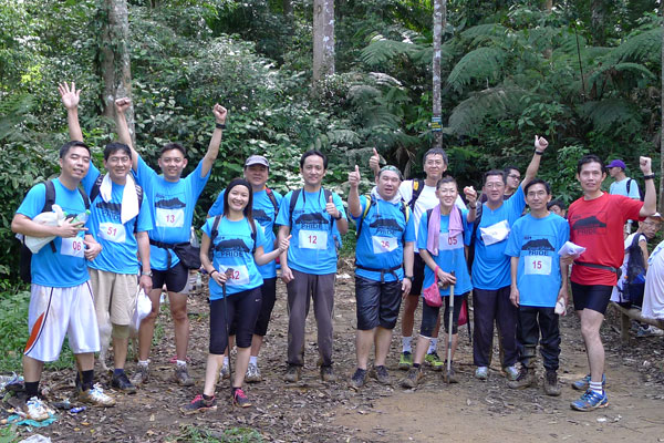
 Registration and collection of race package

All the participants from the Bank were seen excited and in exuberant mood. The 55 participants were there for the qualifying round to be selected for Mount Kinabalu Climb – fully sponsored – in October 2013 in commemorating the Bank’s 100 Years Celebration. They were busy with the registration, getting the race kit, pinning the bibs on the blue dryfit T-shirts, getting the breakfast pack, and busy chatting with other colleagues.

The marshals in red T-shirts, at a different corner, were busy with their final briefing on their designated tasks and activities. They were also busy with synchronizing and testing the walkie-talkies and stopwatches. 

First batch of participants arriving at Chekpoint #1 - The Pondok (the Leading Marshals, Sam and KC at left)

Support crew - There were 11 marshals (these are non-bank staff), 3 marshals (yours truly is one of them); 4 volunteers, and 2 official photographers. One medic van and medical team was on standby at the car park.

The event was graced by the Bank's Managing Director; in his opening speech, apart from the brief business announcement, he informed that his hometown is from Pangsoon, Ulu Langat area - where Gunung Nuang is located.

After the Organizing Chairperson's opening address; after MD's speech; it was my turn to brief on the safety instructions.

Proceeding with 3rd stream crossing en route to Kem Pacat

Safety Instructions

a. Ribbon markers - the marshals will tie them on the left of the trail for ease in identifying them; following the ribbon markers would lead one to Kem Pacat, our destination;

b. Buddies - always walk with a buddy (or buddies) to take care of one another (especially those new to G.Nuang) and NEVER WALK ALONE; 

c. Timing - Longer qualifying time to ensure a less strenuous journey; this is not a racing event to see who is strongest or fastest. The Leading Marshals, yours truly and Sam, were going up the mountain same time with the contingent and arrived at Kem Pacat to record their timing. If the participants outrun or out-walk the Leading Marshals, they still have to wait at Kem Pacat. The statement connotes slight unfair advantage which drew a bit of laughter ... :-)

d. Marking of attendance both ways - this is to ensure accountability for the entire contingent, and no one is left behind in the mountain

e. Four Streams Crossing - ensure electronic gadgets are kept in airtight plastic bag; ensure loose spectacles are securely fastened. It would become a problem when one slipped and fell into the water.

And a bonus tip of how to avoid leeches.

Recording of timing at Kem Pacat ... Roxzana and yours truly

The weather was fine that morning after the previous evening's rain. However, the ground was wet and slippery that hindered the descending journey. From the traces of marks, I was sure many would have slipped.

Ascent the Mountain

After spending time in taking photos along the journey, many of the participants were ahead of me. So I have to pump up the throttle and climbed in swifter pace to arrive at Kem Pacat. Many trekkers were seen going up the mountain along the narrow trail between Kem Lolo and Kem Pacat. Overtaking them required a bit of time as certain part was narrow. Arriving at Kem Pacat, I was glad that I was still the first person in arriving there: still having 10 minutes of time to wait for the arrival of first participant.

Some of the participants who arrived at Kem Pacat

At Kem Pacat

Many of the participants were first time climbing Gunung Nuang. They were pleased to see that their timing was within the qualifying time.

As usual, we saw the two white dogs were there at Kem Pacat. This time, they have more food to eat. I was surprised to see a cute puppy was hiding below the makeshift shelter. The mother dog must be away busy looking for food. Born in the jungle, this puppy would have to endure a lonely, tough and challenging life. I threw a few pieces of bread near him but it did not seem to recognize the food.

I was waiting alone at Kem Pacat while the other participants, after having rested long enough, began to descend the mountain. After the expiry of qualify time, I was ready to leave and I was surprise another three lady colleagues still managed to arrive at the destination.

Cute puppy below the makeshift tent

Descent the Mountain

After about 15 minutes of running down the mountain, I met one of the sweepers who accompanied a slow lady participant. After recording her timing, according to rule, all have to descend the mountain after the cut-off time. I was told by the sweeper that another four slow participants also could not qualify at Checkpoint #1.

There was a bit of drama as the slowest lady was taking much longer time to descend the mountain. So the Organizing Committee at base activated the Motorbike Emergency Evacuation to shorten the time for a person to walk from the last pondok back to car park. It was a run-down cub-chai motorbike – but it worked!

Immaculately scrubbed - Roxzana spending time at the stream on the descending journey

The event was over at 6:00 p.m. as planned. There was no untoward incidences and all activities took place according to plan. Arising from this outdoor event, we get to know more colleagues from other regions and other divisions. Bravo to all the organizing committees who have spent much thought into staging this event and to ensure the safety of all participants. Bravo to all the marshals and volunteers who have assisted in the various tasks. Bravo to good teamwork in ensuring the success of this event! 


The returning journey

Do click here to view all previous postings at Gunung Nuang.

Posted by KC Leong

Saturday, May 25, 2013

Gunung Nuang

Trekking/trail running at Gunung Nuang with trekker friends and a few bank colleagues on Friday, 24 May 2013. Total distance from car park to Kem Pacat is 19km; time taken is 7 hours while waiting for a few of the slow trekkers who are first-timer to G.Nuang.

Do click here for photos courtesy of yours truly (KC Leong).

 A group photo with trekking friends and bank colleagues at the Main Gate of Gunung Nuang. (left): Chen, Terry Yap, LimCS, HoWG, Roxzana, Fauzi, Ya Hooy, Eric Lee, KhooBY, George.

One commendable effort by a trekker is YaHooy, a young and determined trekker, who is motivated to go to the peak – never mind that if she is alone! She started same time with our group and moving swiftly to the destination. I met her 7 hours later at the car park again. She managed to arrive at the peak in 3.5 hours. At the peak, Kwan Weng, ChooTS and group offered her lots of food to eat that she never have to feel hungry at all ... :-) 

Mountain Dogs – Another observation that I must mention here is the commendable effort by two white dogs, a male and a female. They have chosen to follow us – for unknown reason – from the car park all the way to Kem Pacat crossing 4 streams with us just to earn some food to eat!

 By the river side 

So next time, if you happened to go to Gunung Nuang, please bring more food to spare. Oily and chilly stuff would be bad for dogs. Chicken rice with the aromatic fragrant would be appetizing for them, never mind that you are feeling hungry and giving away your "kai fan"... :-) 

Visitors – At the base pondok after descending the mountain at 3pm, I have the chance to chat with a ranger who was on duty. I commented that there is a noticeable increase of trekkers coming to Gunung Nuang. According to him, there are 300 to 500 trekkers or visitors (per day) during the weekends!

Ya Hooy ... a determined trekker going to the peak 

Emergency evacuation – At that moment, another group of young Chinese trekkers were asking for help as they received a distress call that one of their friends was unable to descend the mountain (between Kem Pacat and Kem Lolo). So the ranger dispatched a rider who then rode an old cub-chai motorbike for the rescue. The look of the run-down cub-chai did look comical to me; never mind, they know what they are doing and that must be the tried-and-tested rescue vehicle! When I chatted with Ya Hooy who later descended the mountain, she said she saw a young and big-sized Chinese guy assisted by his two friends. Sitting on the ground, the exhausted young man was too weak to walk. 

At the signature tree of Kem Pacat; yours truly (KC) at right.

Gunung Nuang – With the 3-tier terrain stretching as far as 25km to the peak (round trip), Gunung Nuang at Ulu Langat is by far the most challenging and easily accessible mountains in Kuala Lumpur. The trekkers, trail runners or even tourists are here either for recreation at waterfalls or for training purpose preceding a tough mountain scaling event.

Next Saturday, 1 June 2013, I shall come to Gunung Nuang again with 60 bank staff that will undergo a final selection process for qualifying to be selected to go up Mount Kinabalu in October 2013 (fully sponsored), in commemorating the Bank's 100 Years Celebration.

 Many people at Kem Pacat

 hmmm... the bread must be tasty to eat; please, please give me a little ... I am hungry ...the dog must be thinking. Model for this photo: Miss Chen.

 Hold on to this stick! A good challenge for not wetting the shoes or not falling into the stream due to slippery stones for landing


Roxzana ... having a good scrub by the stream, even the Nike shoes some more ... :-)

Round trip (from car park to Kem Pacat) is 19km in 7 hours in waiting for the slower trekkers.


Do click here for all other postings of Gunung Nuangs. Scrow down the pages.


Posted by KC Leong

Sunday, May 19, 2013

Bukit Gasing Trail Running

Trail running with a small group of runners at Bukit Gasing on Sunday, 19 May 2013. The mission: ChongYF and I recce and try to get a better understanding of the various trails of Gasing Hill. Total distance: 6.6km in 2 hr 30 minutes. 

Do click here to view photos courtesy of yours truly (KC Leong).


 (left) Chong YF, Ya Hooy, Eric, Phoebe, TanHC, KC Leong

 At Kerinchi Park area ... look at the amount of rubbish left behind after the picnic by the public

 Look at the sweat

 At the side of Indian Temple

Ya Hooy refreshing at a stream

The route: From Bukit Gasing cross over to Kerinchi Park; returned to Gasing Hill passing by the 3-Bench route, then 2-Bench route to Suspension Bridge; return to Watch Tower via the Fencing Area. Cross over Indian Temple Hill; continue to Sewage Plant, passing by Reservoir and return to the Gasing Hill Main Entrance.


Posted by KC Leong


Saturday, May 11, 2013

Apek Saga Hills

Trekking with Bandar Utama Trekkers Team (BUTT) and Mount Semeru Team trekking at Apek - Saga Hills on Saturday, 11 May 2013.

Do click here to view photos courtesy of yours truly (KC Leong).


According to Joseph Yong, team lead for Mount Semeru trekking (Indonesia, 20 July 2013, 10D9N), the team is still looking for one more lady trekker. I am joining this team also.


Do click here for all latest postings at Apek Hill Cheras.

 Trekkers in Black - still reeling from the disbelief and shock of hearing the results of 505

 At Apek Hill waftefall

 A young lady helping friends to capture the moment while they enjoy the natural massage from the weight of falling water 

 A group photo at the waterfall

Back (left): KC Leong, SC Yong, Vince, Jason Lee;
Middle: Kathy, LimBB, Elaine, Jenny Lee, Joseph Yong;
Front: WongFK, Alvin, Kelly Hoh, Hee, George

 1M_Team ... Having fun at Saga Hill station

The 'keng chow' lady trekkers


Note: other than reeling for 505, when in the jungle, try to wear bright colour apparel for correct identification of one's presence. While the group traversed from Saga Station to Station 6 (of Apek Hill), I was running in front. After a while, I was alone along the path meandering through the dense tropical vegetation with sunlight partially blocked by the trees above. At one point, when I took a quick glance backward, I could see a dark moving image about 30 meters behind me. I would want to believe that one of the team members was trailing behind. Imagine that it is during a ghost month ... :-)


Do click here for photos courtesy of Joseph Yong.

Do click here for previous postings at Apek-Saga Hills.


Posted by KC Leong

Friday, April 26, 2013

Lucky Valley (part 2)

Lucky Valley Retreat and Sungai Lembing Tour, 20-22 April 2013 with Zhineng Qigong (M'sia) members. 
Organizer: KC Leong, Cindy Lim, Grace Lim. 
Chi gong laoshi: Alan Yu laoshi from USJ 15 Wawasan Centre. 
Group size: 35 persons.

Do click here to view complete photo album at Lucky Valley (226 photos) courtesy of yours truly (KC Leong).

If you prefer to view in the original Picasa mode (with captions), wait for about 3-5 seconds, this instruction will appear at the top of display: Click here to go back to Picasa Web Albums.

Stay tuned for more photos at Sungai Lembing tour.

 Lucky Valley Resort near to Muadzam Shah, a town located in the district of Rompin, Pahang … Cindy Lim.

 Moon Walk chi gong in The Energy Pyramid … walking very slowly, this is to direct the chi to the feet

 A bee is busy harvesting nectar and pollen on one of the many water lilies 

 Experiencing the resonance of sound at the centre of the dome of this pagoda

Looking for chi bubble at 5:45 a.m. (Day2) … Only one small bubble at the right of photo frame.

One of the members shine a beam of light into the sky from a powerful torchlight. We saw that the air looks dusty and full of tingling and shining particles. It could not have been dusty as there is no exhaust fume or pollution here. Refer photo album for other bubbles photos.

 Day2 at 7:00 a.m. start of trekking; the starting point is just next to the Pyramid

 What a creative way to cross the stream without getting the shoes wet … Shirley … :-)

 Well guarded … putting on socks and shoes under the watchful eyes of the resident dog which is friendly and always leading the pack looking for lurking danger (possibly from wild boar or wild chicken) … :-) 
The dog is so well-versed with the terrain that it can lead those lost trekkers back to the resort. However, if one walks away from the resorts (not the path to return), it won’t follow. 

 Okay, all crossed the stream and ready to continue with the trekking journey … (left) Cindy (with the brand new Salomon XR trail running shoes), S.Heng, Lum, Camelia, Joanne Wong

 Arriving at the Lords of the Ring Gate… background is the outer perimeter. 

 After 2.5 hours of trekking, it is a superb idea for Alan Yu laoshi to conduct the Sleeping Chi Gong (in a pre-determined posture while repeating a mantra silently). 
With such a nice feeling relaxing on the cool flooring, I am not surprise to hear two members who were snoring for a while … :-)

 The no-frill dining area

 All the 35 Zhineng Qigong members came in this specially chartered coach. 

 Yeah, thumbs UP !! Simple but delicious home-cook food - Kampung chicken and steam fish. Look at the size of the chicken feet (in the small bowl).


Trekking distance: about 9km; time: about 2.5 hour; from the trail map charted by Garmin GPS-enable watch, the perimeter (in red line) of Lucky Valley is in a rectangular shape occupying 500 acres of land.


Do click here for my first visit to Lucky Valley (in blue sky) and the official description and GPS location of Lucky Valley.


Posted by KC Leong


Thursday, April 25, 2013

Sungai Lembing Tour


LV Part 3 - On Day3 morning (22 April 2013, Monday), the Zhineng Qigong group woke up at 2:00 a.m. getting ready for another different outing. This time, we left Lucky Valley (LV) for Sungai Lembing (LB) to see sunrise.

The specially chartered coach, which has been parked there since arrival at 11:30 a.m. on Saturday, departed at 3:00 a.m. as planned.

The journey to LB required 2.5 hours; the group have a simple biscuit-and-packet-Milo breakfast in the bus 30 minutes before reaching LB.

The group started the ascent at 5:45 a.m. and arrived at the top of the Panorama Hill at 6:30 a.m. – a superb timing ready to view sunrise.

Do CLICK HERE to view 89 photos courtesy of yours truly (KC Leong).

 Beautiful ray of light

 One of the group photos … do refer to photo album for other photos

The sea of mist/clouds below the coloured sky

 On the other side of the Panorama Hill is a totally different scene … the misty effect
 A light tint of blush on the right of photo frame
 After the first ray of light, we thought that would be end of the sunrise. We were surprise that the sun turned into golden egg yoke – what a unique scene!
 According to the locals who have tried a few times to view sunrise, today’s scene is beautiful. We must be lucky … after visiting Lucky Valley … :-) At 7:15 a.m. the sky becomes bright and almost all the people have descended the hill.
 The signature old tree of LB town (which is just in front of the market place)
 On the left is the market place. This is the road that leads to the Panorama Hilltop.
 Visiting the famous noodles shop – the unique method of mixing the dough. 
The rod is pivoted at one end and a worker – in this case, our male model – bounced up and down to compress the dough … :-)
The correct method is to stand on one leg and using the thigh area to press the rod down.
Do not practise at home without any supervision as wrong method may cause unnecessary injury (say, standing on two legs to press the rod down) … :-) 
 Suspension Bridge – connecting the village to the main road. The group return after buying the local produces. 
 ALL THE HAPPY FACES – Visiting Gua Charas which is 30 minutes out of LB town en route to Kuala Lumpur.

We arrived at Genting Toll at 5:00 p.m.; due to traffic jam at Middle Ring Road 2, we finally arrived at USJ Taipan at 6:30 p.m.


Do click here for the previous part at Lucky Valley (LV).


Posted by KC Leong