Bukit Dinding Hike
Saturday, 5 July 2025
Distance: 10km;
Elevation gain: 721m;
Total time: about 6 hours.
(Data from Strava)
CLICK HERE for WikiLoc trailmap of KL See See and Kazumi Otai trails.
Photos below: click on the image for actual bigger file size display. (Photos courtesy of ChanHN, Helen Khoo).
Group photo at the trailhead
After completing the challenging hike of Mini Tahan trails, the team emerged at a junction of a tar road for refreshment break. This tar road leads one to the peak. After that, we walked to the peak for photos shoot.
We entered the KL See See (for KLCC) trail to return to carpark. We passed by the first view point: City View Look-out Point. The trails are well-marked; we just followed the pink markers.
Mini Tahan trail is with steep uphill and downhill slopes
We arrived at another viewpoint: Setiawangsa Viewpoint. Here, there are tables and chairs for resting or enjoying the nice view of the city skyline. After that, we followed the orange markers for Kazumi Otai trails. Returning to carpark via this trail is challenging: other than the steep descent, there are a few steep ascents. Imagine when one is already tired, one still has to hike up a few steep slopes.
The iconic tree of this Mini Tahan trail
This combination of trails – Mini Tahan, KL See See, Kazumi Otai – is excellent for tough training, even better than Bukit Kiara or Apek Hill. The Mini Tahan trails are not suitable for beginner hikers - tough and technical. There were two mobile drinks stations selling drinks. If the elevation gain is still not sufficient, one can always do another reversed loop. 😀
Having refreshment break after emerging from the Mini Tahan trail. The tar road leads one to the peak of Bukit Dinding
In high spirit
We enter this trail to return to carpark ... homonyms: KL See See = KLCC Building
The first look-out viewpoint
The second look-out viewpoint - Setiawangsa Viewpoint
Kazumi Otai Trail - with steep slopes
Descending the challenging rock face
Yeah, we did it !!

Compare Blue Trail and the KL See See Trail and Kazumi Otai Trail
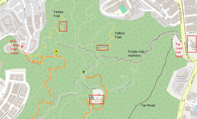
When we were hiking Mini Tahan trails, at one point, we would see the convergence with Purple Trail. From the trail map, the Purple Trail starts from the other trail head (where vehicles can follow the tar road to the peak).
Posted by KC Leong


 Compare Blue Trail and the KL See See Trail and Kazumi Otai Trail