Monday, June 06, 2022

Gunung Tahan Hike 2022

Being a Malaysian, one must try hiking up Mount Kinabalu – because it is there. Likewise, if one has the enthusiasm, one must challenge oneself by hiking up Gunung Tahan. Standing at an elevation of 2,187 meters, it is the highest peak in Peninsular Msia, or G1 of the G7 mountains. This mountain is considered by many to be one of the toughest treks in Peninsular Msia. From Merapoh side, one has to cross a total of 8 streams/rivers, climb steep rooted paths, step on muddy puddle to arrive at the destination. 

Do CLICK HERE to view 220 high-resolution photos courtesy of your truly, KC ... in this photo album, it also contains photos contributed from the team members. 

Declaration of personal items at Sungai Relau Park Office ... Shu-Lin, KC, Sabrina.

Gunung Tahan trip from 28 May to 2 June 2022 (6D5N) itinerary

Day 1 - drive to Merapoh; overnight in a hostel;

Day 2 - declaration of personal items at Sungai Relau Park Office; 4WD transfer to Kuala Juram trailhead; camping at Kem Kor (750m);

Day 3 - camping at Kem Kubang (1,406m);

Day 4 (31 May) - arrive at Kem Botak (1,943m); ascent to summit; viewing sunset; camping at Kem Botak;

Day 5 - descent from Kem Botak to Kem Kor; final camping at Kem Kor;

Day 6 - return to Kuala Juram trailhead; 4WD transfer to Sg Relau Park Office; inspecting/tallying of personal items; returning to Kuala Lumpur; dinner in Bentong.

Journey of a thousand miles starts here 

Team members (15 hikers)

KC Leong, Chan How Nean, Ong Soon Aun, Cheng Li, Leong Kee Wai, Sou Kuan Yin, Wey Tyng, Ng Lay Keong, Josephine Lee, Shu-Lin, Rachel Thang, Felicia Hew, Sabrina Lim, Dr Kogulan, Terence Phuah. 

Seven rivers/streams to cross before arriving at Kem Kor; after Kem Kor, there is only one stream to cross, that may not get the shoes wet

Distance

(1) Merapoh - peak - Merapoh = 32km x 2 = 64km;

(2) Merapoh - peak - Kuala Tahan (Trans Tahan) = 32km + 55km = 87km. 

For journey (1), the returning is mostly downhill; for journey (2), there will be more mountains to ascend, deeper rivers to cross en route to Kuala Tahan. If you have not tried this Gunung Tahan trails, don't ever think of doing Trans Tahan in your first attempt.

Three flavours of Gunung Tahan journey

(1) Merapoh - peak - Merapoh (32km + 32km = 64km);

(2) Trans Tahans (32km + 55km = 87km);

(3) Kuala Tahan - peak - Kuala Tahan (55km + 55km = 110km). 

Lunch break after crossing Kuala Luis river

Tahan Personal Porter Services

Each porter would carry a 15kg net weight from the hikers that engage porter service. For a 5D4N hiking and camping trip, the fee is RM1,300 per porter. It is best to share a porter, say, 1/3 share (5kg), or 1/2 share (7.5kg) among hikers. The items for porters to carry must be protected in plastic bags to avoid getting wet; a simple big shopping bag, say, from Ikea or Decathlon would be good to contain all the necessary items when handing over to the porter. The porters would then stuff all these items individually into their own rucksacks.  

Located just by a stream with clear water, Kem Kor is the most beautiful campsite throughout the entire journey ... OngSA and NgLK

Backpack Weight

This is a tricky consideration. If one is carrying a few extra kilograms of weight above one's comfortable level, the backpack would weigh one down. Hence, one must seriously test the actual load of the backpack, and for a few continuous days of local training. Allocating 5kg of personal items for porter to carry would ease one's load considerably. I was carrying all stuff myself with a total weight of 15kg. Though I could handle the load, the additional weight from the backpack altered my centre of gravity and threw me off-balance a few times.    

At second campsite - Kem Kubang; here, space is limited, and water source is 10 minutes away

4D3N or 5D4N

Most hikers would take the 4D3N journey thereby from Kem Kor to Kem Botak (Day 2 of the hike) is completed within a day. This choice is tough as the distance is 16km, and there is almost 1,200 meters of elevation gain; not forgetting one has to carry the heavy weight of backpacks. Most hikers would take 10 to 12 hours to hike from Kem Kor to Kem Botak. For an additional day (5D4N type), the journey involves extra camping at Kem Kubang, and the journey is less strenuous. With extra day, it is possible to summit from Kem Botak within the same day, enjoying the sunset; and leaving next morning to have direct descent from Kem Botak to Kem Kor.   

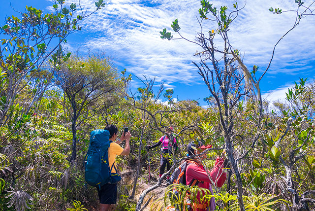
Good weather and lots of blue sky ... at Bonsai areas (left) Cheng Li, Sabrina, Wey Tyng, Josephine, Shu-Lin, Rachel.

Training 

Not all training grounds are the same: for close to Gunung Tahan conditions, one has to train at the stretch between Kem Pacat to False Peak of Gunung Nuang. This part of the terrain is steep and steps are wide, require to use both the arms. While training, one has to carry almost the same amount of intended weight of backpack. With sufficient training, one would enjoy the journey of this Gunung Tahan trails. Another good location for training in Kuala Lumpur is the Mini Tahan Trail in Bukit Dinding (Wangsa Maju area) with the steep slopes for ascent and descent. 

Meandering through the trails of Bonsai areas ... ChanHN, Wey Tyng, Cheng Li.

Handling Covid-19 New Norms 

Before the group departure on Sat 28 May 2022, all team members must perform RTK Covid-19 self-test on the morning of 28 May, or one day earlier, and published the results in the chat group. Also, five days prior to 28 May, all team members must observe SOP (distancing, masks, etc) to avoid contracting the virus and only developed symptoms after the group had started the journey. Once this process was done, we only have to focus and tackle the tough journey and not be bogged down with the worry that agonize us for the past two years. 

Between Bonsai area and Kem Botak ... Wey Tyng, Cheng Li and Josephine

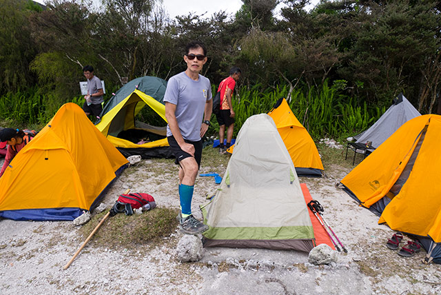
At Kem Botak ... as the name indicates ... it is barren and bright at this campsite

Yours truly, KC Leong, with the Kelty Salida 1-man tent

Continuing the journey from Kem Botak to the peak

Yeah! We finally made it to the peak of Gunung Tahan!

A group photo with the mountain guides, Wan Adham (right) and Rosni Mamat (Left 3)

Vibrant sunset viewed from Kem Botak campsite

A unique view with the clouds hovering so near us

Finally, with the certificate of completion/achievement

A schematic diagram illustrating the entire journey (click at image for bigger view). 

Trekking Agent ... 

Green Trekkers Sdn Bhd;

Ms Wong; +6016 2898 260 / +6013 3365 628

Posted by KC Leong

Monday, May 09, 2022

Gunung Nuang Hike

Hiking up to the peak of Gunung Nuang is tough. From Kem Pacat to False Peak, the terrain is steep, the steps are wide. One needed to twist and turn the body in order to get a safe landing before putting the foot forward. One also needed strong arms to pull the roots or ropes in order to gain the next steps. 

Do Click Here to view high-resolution photos courtesy of yours truly, KC Leong.

Group photo at the trailhead entrance

In the wee hours of Saturday, 7 May 2022, it rained for two hours before we started our hike at 7am, making the ground wet and slippery that add on to the difficulty.

Together with the wet condition was the abundance of leeches – most active when the ground was wet – readily wanting to have a good feast of the blood.

Another group photo

We did not give up when challenged by adversity: we safely summited and then returned to trailhead at 6pm, completing the memorable journey in 11 hours. I reckon that it is good to do 2 or 3 times of Nuang peak per year to test whether the body is still in good working conditions 😀
Taking a rest and making hot drinks at Kem Pacat

Norrmal pace timing:

Trailhead to Kem Lolo = 1 hr 25 min;

Crossing 4 main streams = 30 min;

Kem Lolo to Kem Pacat = 1 hr 20 min;

Kem Pacat to False Peak = 1 hr;

False Peak to Peak = 30 min.

Descent from peak at 1:30 p.m.

Returning from Peak to Kem Pacat = 1 hr 15 min (gain 15 min).

One way to the peak took 5 hours.

The signature tree with a huge vine was gone

Arriving at Gunung Nuang peak

Claudia, Shu-Lin, Felicia, Rachel

Cooking instant noodles at the peak

Easy yoga pose at the peak by Claudia

Another angle of Nuang peak

Posted by KC Leong

Thursday, September 24, 2020

KKB Paragliding Site, Bukit Batu Pahat and Batu Belah

The recce hike on Wedn, 23 Sept 2020 at Kuala Kubu Bharu (KKB) has a few nice spots for photo shoots – the paragliding site, Batu Pahat and Batu Belah. Batu Pahat site is just next to the paragliding site, but Batu Belah site is another 500 meters further down the hill towards the Indian temple side.  

Do CLICK HERE to view 120 high-resolution photos courtesy of yours truly, KC Leong.

Note: the advertisement (in between the posting) is inserted by Google which I have no control over them (and I could not disable them).

Trail head from Taman Tasik Milenium 

Not knowing the terrain, we – ChanHN, Henry, Irene, Nelsson, Gillian Ong, Felicia Hew and yours truly – actually did a Trans Exploratory hike: we hiked up to the peak where the paragliding take-off site is situated; then descended the hill to the other side of the hill (where there is an Indian temple); then back track to the peak, and descended to the trail head. The route from Taman Tasik Milenium is following the 4WD yellow-earth road; whereas the trail from Indian temple is a fairly steep hiking trails. Started at around 8am, we returned to trail head at around 2pm. 
At the paragliding site of KKB ... (left) KC Leong, Felicia Hew, Henry, Nelsson, Irene, ChanHN, Gillian Ong.

GPS Google Maps Drop Pins:

Trail head at Taman Tasik Milenium:

From the Sri Muneeswarar Veerapathra Kaaliamman Temple:

Batu Pahat site

Batu Pahat site is just next to the paragliding site
The mini Batu Belah
The actual Batu Belah site (this rock is as big as the Wave Rock in Kuala Pilah)
Our pretty models posing for the camera ... Felicia and Gillian
The Indian temple at the opposite end of the trail head (the trail is at the right of the photo frame)
A solo paraglider taking off from the site
Another solo paraglider taking off; for beginner, there will be an experienced operator accompanying in the flight (tandem paragliding)
A beautiful sight ... with Felicia in the foreground
Click on the map for actual big display

Posted by KC Leong

Monday, September 14, 2020

Gunung Besar Hantu and Lata Dinding

Hiking Gunung Besar Hantu (GBH) and Lata Dinding on Sunday, 13 Sept 2020 ... This was my first time hiking this mountain in Negeri Sembilan and I find this mountain is as challenging as Gunung Nuang. At an elevation of 1,462m, GBH is about 30 meters lower than Gunung Nuang.

Do CLICK HERE to view 68 high-resolution photos courtesy of yours truly, KC Leong.

Note: the advertisement (in between the posting) is inserted by Google which I have no control over them (and I could not disable them).

A group photo at the trail head of GBH
(left: KC Leong, Edance, Felicia Hew; Vindy, Sylvia Ong, Tee Kong Tiong)

The reason that many of us have never hiked this mountain was due to the travelling time, and also it is being over-shadowed by Gunung Nuang. From the Google Maps, the direct distance apart between Gunung Nuang (Pansoon) and GBH trail heads are just 12km away. But the travelling time is almost double compares going to Nuang trail head. Arriving at GBH trail head, one has to travel through the zigzag country road; many kilometers before reaching GBH trail head, the road is just gravel and dirt (not tarred) and not pleasant to drive. Travelling time from Subang Jaya to GBH trail head is 2 hr 15 min. Make sure the petrol tank of your car is at least half filled as there is no petrol station for hundreds of kilometers.

Gunung Besar Hantu, Gunung Kecil Hantu, Lata Dinding waterfall - go straight;
Lata Kijang waterfall is to take the left road

The first section of the hike was walking on 4WD gravel road gradually gaining in elevation. There is a big and flat clearing with the name Kem Orkid as wild orchid flowers were seen flourish there. After Kem Orkid, it is steep ascent until GBH peak. In order to hike this mountain, one must undergo training in hiking around 5-7 hours; otherwise, one would feel the tiredness at the end of the outing.

View at the peak - the view at GBH is not attractive as the view is blocked by the trees, compares to Gunung Kecil Hantu (GKH) with a better and unobstructed view.

Arriving at Kem Orkid

When we arrived at Lata Dinding waterfall at 3:30pm, all other hikers have left; we have the whole waterfall to ourselves. Contrary to a hiker friend's previous experience at Lata Dinding where there were many leeches, on that afternoon, there was not a single leech. Even with the wet ground that day, there was not any leech at all.

At Gunung Besar Hantu peak; in order to be able to see the mountains in the background, one has to climb on to the tree and the fallen structure

Accomplishing GBH and Lata Dinding in a trip requires one to hike moderately fast pace in order to return to trail head before dark. Below is a popular mix for a day-trip:

(1) GBH and GKH together (distance apart of two peaks is only 1.5 km);

(2) Lata Dinding and Lata Kijang together (via 4WD road; gradual slope).

Enjoying the cold water at Lata Dinding waterfallThe majestic Lata Dinding waterfallSecurity guard checking before entering the park

A lot of parking space within the park; directly opposite is the toilet; behind the toilet about 50 meters away, there is a suspension bridge where the campsite is located

How to apply permit:

(1) Obtain permit on-site at the park office - one can only clear security guard and enter the park at 8am when the ranger reports for work; for long hike, this method is not favourable due to late start;

(2) Apply online - write email to Negeri Sembilan Forestry with the participant names and particulars; once the officer confirms the submission, payment can be done online upon advised with the bank account number. With the proof of transfer of payment, permit would then issue (communication via email). With the permit, the security guard would allow entry into the park even before 8am;

(3) Permit fee = RM5 per person.

Jabatan Perhutanan Negeri, Negeri Sembilan Darul Khusus

Tel: 06 - 7659875

Email: hutanns@ns.gov.my

Website: forestry.ns.gov.my

There is a nice campsite within the park, permit fee is also RM5 each person. The two buildings at the background are the toilet

GBH Trail map showing two peaks and two waterfalls (click on the map for a bigger display)

Duration for GBH and Lata Dinding:

A-B = 30 min;

B-D = 2 hr 20 min;

D-E = 1 hr 15 min;

E-F = 25 min;

A-F = 4 hr 40 min (GBH);

C-L = 1 hr 15 min (Lata Dinding).

We started the hike at 7:15am, returned to trail head at 6:30pm with a round trip of 11 hours.


Round trip distance:

GBH + GKH = 22km;

GBH + Lada Dinding = 30km;

Lata Dinding + Lata Kijang = 25km.


Google Maps Drop Pin:

Click Here for trail head of GBH and GKH (Taman Alam Liar Negeri, Kenaboi) ...

https://goo.gl/maps/bft2VejvFZmBnvP16


Feeling hungry after the hike, we drove to Titi town for dinner, about 35km away on straight route. If we returned to Batu 14 Hulu Langat area, we need to travel 60km of winding route, that would take much longer time. Drop pin below is the Chinese restaurant that we went in Titi town; there are a few more restaurants nearby.

Click Here for Google Maps drop pin to Sin Wong Kok Restaurant.

https://goo.gl/maps/wPMmQn3pcoCKodDH7


New update on 20 April 2021 ... according to CL Chong, his group went there for camping at the new camping hall, located not far from the existing camping ground. Booking of entire hall cost RM200 per night, complete with electricity, water and toilet. Photos below courtesy of CL Chong.

A newly erected camping hall, good for wet season camping 
A new kitchen complete with electricity plug points 
Location of various facilities


The sifu Mr Tee Kong Tiong:

We have the opportunity to meet Mr Tee Kong Tiong in this hike, the senior who was lost in Mount Korbu for three days sometime on 2 Aug 2020.

To summarize that incident, he concluded that "puteri blinded his vision and thoughts". At one y-fork junction, there was a clear trail on the left but he entered the not-so-clear trail on the right. After a few hours, he arrived at another campsite, and decided to stay overnight as it was almost in the evening. Then next day, he continued the wrong path. It was during the end of the second day, then only he realised that he was on the wrong path. 

During the conversation, he said that it did not occur to him that there were 16 ladders to climb and he did not see any of them (when walking in the wrong path).

Posted by KC Leong